Firsanovka - Serednikovo estate. Firsanovka - Serednikovo estate Review of the route
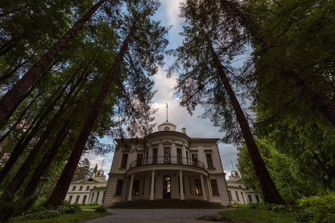
The Serednikovo estate (formerly Srednikovo) is located in the Solnechnogorsk district of the Moscow region, next to the Mtsyri sanatorium village, and is directly connected with the name of the Russian writer Mikhail Yuryevich Lermontov.
The history of the estate begins in 1775, when Senator Vsevolod Alekseevich Vsevolozhsky decided to build a state house with outbuildings in the village of Serednikovo. Almost the entire architectural complex of the estate appeared under him. After Vsevolozhsky’s death, his nephew took possession of the estate, then his brother, then Colonel Afanasy Nesterov, Count Grigory Saltykov. Finally, in 1825, it was bought by Dmitry Alekseevich Stolypin, brother of Elizaveta Arsenyeva, Lermontov’s grandmother.
For several years, the grandmother has been bringing her grandson to Serednikovo, where his talent as a writer is revealed. Since 1869, the estate has belonged to the Firsanov family. In 1918 it was nationalized, in 1925 a sanatorium for nervous patients was opened, and in 1946 an anti-tuberculosis sanatorium “Mtsyri” was opened.
Serednikovo Estate on Google Panorama
Since the second half of the 20th century, the estate fell into disrepair. In 1993, the “National Lermontov Center in Serednikovo” was formed, and by the early 2000s, restoration work was completed.
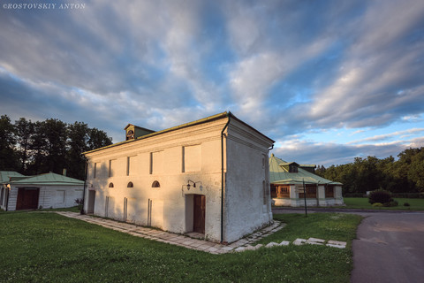
The estate complex of the 18th-19th centuries, made in the classic style, includes a main house with a belvedere, four two-story outbuildings, cattle and horse yards, a carriage house, and an arena. Since the buildings were rebuilt several times, the Serednikovo estate looks different inside; the interiors have been partially restored. The complex also includes the 17th-century Church of St. Alexius, a greenhouse and the film city of Piligrim Porto with scenery from 18th-century England.
The estate hosts various events for visitors of all ages.
- Quest “Bunker Escape”. An extremely popular quest in the Serednikovo estate - 20 rooms with different interiors, from 3 to 8 hours of continuous action, up to 300 participants playing simultaneously. .
- Leisure. You can play paintball, airsoft and laser tag, take a sightseeing helicopter flight, or rent a barbecue area.
- Excursions. Sightseeing tours are held around the Main House of the Serednikovo estate (schedule). Individual visitors do not need to register, while for groups of 15 people or more a reservation is required (themes vary). The duration of the excursion is 1 hour.
- Festivals. The Midsummer Night’s Dream costume ball and the “Lermontov Holidays” summer promenade ball are held on the estate’s territory.
- Hosting an event. Traditional services are also offered - a wedding at the Serednikovo estate, corporate and special events of any format and theme, graduation party or last call, holiday programs for primary and secondary school students.
Opening hours and ticket prices
The Serednikovo estate is open every day, seven days a week, from 9.00 to 22.00.
Entrance fee to visit the historical architectural complex and landscape park of the estate:
- adults - 100 rubles;
- pensioners - 50 rubles;
- Children under 14 years of age and disabled people are free.
A visit to the State House is only possible as part of an excursion group. The ticket for the excursion is paid separately directly at the Main House:
- full ticket - 300 rubles;
- discount ticket (pupils, students, pensioners) - 250 rubles.
How to get to the Serednikovo estate
You can get to the Serednikovo estate on your own by public transport or car.
From Moscow, you can first get to the Firsanovskaya railway station (trains depart from the Leningradsky station, the approximate travel time is 45 minutes), where you need to change to bus number 40, going to the Mtsyri sanatorium, this is the final station. The bus runs from 05:30 to 22:00, with a day break. The bus schedule can be checked. The total travel time is just over an hour.
If you get to the Serednikovo estate from Zelenograd, then in addition to the train, you can get to Firsanovskaya station by bus No. 7.
When driving from Moscow by car, you need to drive along the Leningradskoye Shosse, then turn off at the village of “Chernaya Gryad” towards Firsanovka.
Exact coordinates of the estate:
Latitude: 55gr. 55’45.03"N (55.929175)
Longitude: 37 degrees. 14’28.38"E (37.241217
To order a car from Zelenograd, you can use mobile applications of local taxi services: for example, “Taxi Bamboo”, “Voyage” or “Taxi24”. Gett and Yandex applications operate in Moscow. Taxi.
Video about the Serednikovo estate:


Show all 19 photos
Video from route markers
Feedback on the route
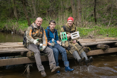
An entry-level hiking trail suitable for a day hike. The ability to start the route immediately from the commuter train station, its short length, simple terrain and lack of elevation gain make this route an ideal choice for those who are just beginning their acquaintance with the basics of hiking. It will also be a good option for organizing walking excursions around the Moscow region for small groups of schoolchildren or students.
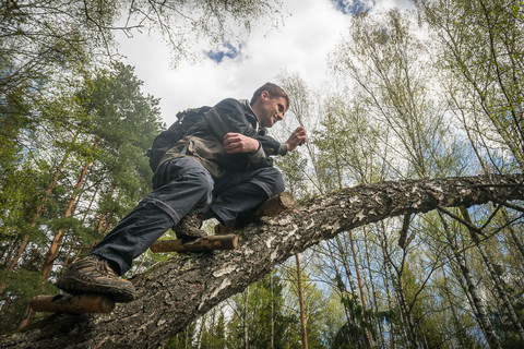
Sections of windbreaks that may periodically form along the route will provide an opportunity to practice skills in passing obstacles and overcoming difficulties along the way.
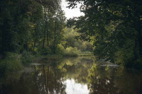
The route passes mainly through forested areas, but also has a section of a small picturesque valley, several crossings over bridges over the Skhodnya and Goretovka rivers. On the route there is the Shchepkino Swamp lake, where the summer open-air ethnic music festival Shchepka has been held for many years.
On the route there is a memorial sign to the Soviet pilot Uralskaya Kella Borisovna, who died in 1952. while performing a mission on Aviation Day, as well as a grave for unknown soldiers who died during the defense of Moscow.
Closer to the end of the route, at the entrance to the village of Serednikovo, there is the Church of St. Alexius, with a holy spring and a bathhouse, and the end of the route leads to the film town “Pilgrim Porto”, where the filming of the film “Notes of the Forwarder of the Secret Chancellery” took place. This site is part of the Serednikovo Estate complex - the main attraction of the route, the former estate of the Vsevolozhskys and Stolypins, whose park and estate ensemble of the late 18th - early 19th centuries is one of the most famous Lermontov places in Russia.
It is important to know
Limitations and Features
Due to hurricane downpours, debris from fallen trees may form along the route; bridges over rivers are sometimes demolished when water spills. There is a ford 50 meters from the bridge over Goretovka in case there is no bridge itself.
There is a kilometer-long section of windfall on the Firsanovka-Malino section from the gas pipeline to the exit to the ski slope.
How to get there
The route runs in the north of the Moscow region.
Nearest cities: Zelenograd, Khimki, Moscow.
Electric trains run to Firsanovskaya station from Moscow (Leningradsky Station, ~45 minutes on the way) and Zelenograd (Kryukovo station, ~10 minutes on the way) all day long, until late at night.
For those who decide to come to the route with their own vehicle, there is a parking lot near the Firsanovskaya station, next to the store.
Places for rest and overnight stays
The route does not include overnight stays. However, if you wish, you can stay overnight with a tent near the Shchepkino Swamp lake. In this place there are several equipped fire pits with improvised benches in the form of logs and a good approach to the lake.
Water
There are no natural sources of drinking water along the route. Take enough water with you.
The shops
You can buy the necessary provisions at the Firsanovskaya station. Take it with you sufficient water and drink so you don't have to worry about it while you're on the road. The route passes near populated areas, which allows you to replenish supplies if necessary.
Don't forget to take it with you
- Good mood.
- Food and drink.
- Mosquito repellents.
Detailed route description
The route is conditionally divided by Malino station into two sections of approximately equal length, each of which can be considered as an independent short route of up to 10 km. That is why you can not go through it completely, but only up to half, after which you can freely travel from Malino station to Moscow or Zelenograd by train. The route is designed in such a way that it can be passed in both directions, but the end of the route will still be at Firsanovskaya station.
The route starts from Firsanovskaya station, along Shosseynaya street. The train schedule is quite tight, so you can go on the route at any time in the first half of the day, and at the same time complete it completely in 4 - 5 hours.
There is a grocery store across the street from the station, so if you forgot your snack or water at home, you can immediately correct this omission.
The first marker of the route is visible immediately upon descent from the Moscow - Firsanovskaya platform in the Zelonograd direction. It's a green and white marker on a pole immediately to the left of the station exit.
In the same direction, parallel to the road, there is a pedestrian path paved with paving slabs, so for the first hundred meters you will have to move along with the general flow of those who came to Firsanovka. Next, the tiled path turns left into a tunnel passage in the direction of the village of Firsanovka, but we continue to move straight, after 40 meters of a small landing we emerge onto an asphalt road.
On the right side of the road there is a trodden path that runs along the road. It’s easy to walk along it and you don’t have to constantly monitor cars, which, although not often, still pass along this section of the road. But after rain, this path sometimes turns into a small swamp - in this case, it is preferable to move along the side of the road.
We move along the road 470 meters, it will lead us to a fork near the small village of Kutuzovskoye. To the left the road goes under the railway tracks, to the right into the village itself. We continue to walk straight along the path, which is clearly trampled from the very fork. The path goes around the village on the left side and goes into a small forest that grows along the railway.
The next section of the path goes in the same direction through the forest, parallel to the railway. After 560 meters, the trail turns to the right, adjoining the dirt road Kutuzovskoye - Firsanovka. The route crosses this road and, leaving it behind, goes along a wide clearing. To the right of the clearing, where it adjoins the road, there is a large training center for dogs, so for the first two hundred meters to the right of the clearing there will be a mesh fence.
This kilometer-long section of the route along the clearing will be the easiest to navigate, but not the easiest to pass, since after the rains the road along the clearing is washed away and in places it turns into small swamps, which you have to go around, going deeper into the forest.
After 650 meters, the clearing intersects with another, much wider one, which was cut specifically for a high-voltage power line. We cross the power line clearing using the shortest route and again enter our clearing, along which we move on for another 400 meters.
Almost at the exit from the forest, in a place where the pipes of some enterprise in the village of Nazaryevo will already be visible from the clearing itself, the route turns sharply into the forest to the left. You can understand this by looking at several markings that are applied to the trees on the left side of the clearing. Here begins the most difficult, but at the same time the most interesting section of the route - through a windfall.
The length of this section is not large, about 300 meters. It is not difficult to navigate through the windfall, thanks to the very frequently applied markings, which in this section, in addition to the standard marks, are duplicated by red markings. The passage through the windfall has been cleared, and in places where there are particularly large rubble, cuts have been made in the form of a path.
After 300 meters, the route makes a sharp turn to the right, towards the village of Nazaryevo, all along the same windfall, with the only difference that here the path becomes even more obvious. There was once a fairly wide road in this place, but after numerous windbreaks it was no longer used.
It is also easy to navigate this area due to the fact that it is used for orienteering competitions, and therefore along the route here, in addition to markings, there are... ordinary plastic bags tied to the trees, which the athletes used as their own markings.
And again, 200 meters of the path through the cuts, after which the path unexpectedly comes out to the Skhodnya river, across which an old bridge leads. The bridge is slowly falling into disrepair, but it will be suitable for walking on foot for several more decades.
Having crossed the bridge, we climb 50 meters up the path and suddenly emerge from the forest onto an asphalt road, or rather a ski slope. Having risen to the highway, we turn left and walk 130 meters along the asphalt to the next forest area, and again to the left of the asphalt we go into the forest area.
The walk is quite easy, thanks to a well-trodden path, which turns smoothly to the right after 260 meters and comes out onto a dirt road. From the junction of the path and the road we turn left and see another bridge, similar to the one we crossed 15 minutes ago.
We cross the bridge and continue along the obvious path, following the markings.
The path after the bridge begins to gradually climb the hill, and walk along the top of the hill, winding parallel to the river at the bottom of the hill. Here the trail will split several times, but we always take the right turn at the fork. After 300 meters, the path sharply goes down into a ravine, after which it also rises sharply up onto a wide dirt road.
On the road we turn right and go down it 120 meters, all the way to the same river Skhodnya, which we just crossed twice. Here another bridge awaits us and one of the attractions of the route.
The fact is that the route itself continues along the river for another 90 meters, after which it turns at an angle of 90 degrees to the left, perpendicular to the river. But if you leave the route for a while, cross this bridge, and on the opposite bank turn left and walk along the asphalt path upstream of the river about 40 meters, then you can go to the grave of Kella Borisovna Uralskaya, a pilot who died while performing a stunt for Aviation Day in 1952.
We return back to the route via the same bridge.
From the bridge we turn sharply to the right and walk along the road 90 meters upstream of the river. Next, we turn left perpendicular to the river, and finally move away from the river. We walk 60 meters along the path and see a small clearing with fallen and sawed trees. The place is ideal for a stop and a lunch break.
We turn into the first one, onto the path, but even if you missed and turned into the second or third, it’s okay - after 400 meters they all come out onto the same very wide, old, broken dirt road.
At the fork we choose the left path, and along the obvious path we begin to go around the lake. After 180 meters the trail comes out into a wide clearing cut for power lines. This is the same clearing that we crossed at the beginning of the route, but a kilometer higher.
We cross the clearing along the path and enter the forest again.
After walking 80 meters along the path along the lake, we come out into a small clearing with an incomprehensible building. This is a wooden tripod, 6 meters high. In the same clearing there is a fire pit, with logs instead of benches and a metal barbecue left.
The most difficult part of the route to navigate begins from this place. The fact is that there is a very obvious path that continues to go around the lake, not very far from its shore. But in spring and autumn, during rainy weather, the lake overflows, turning this path into a good mud swamp. Therefore, you have to go much to the left of the lake in order to walk along dry paths.
Because of this, the route is longer, but allows you to pass it dry and clean.
In general, the length of this section of the route is about 500 meters, but when trying to bypass the flooded areas, almost 400 meters of “extra trail” are added. The main task of this “elongated” section is to go around the lake in a circle so that in the end you still come out on its shore, but on the opposite side from the one where we first saw the lake at the fork.
Here, on the opposite bank, there is a very interesting place - a huge clearing with a makeshift stage and several wooden outbuildings. It is here that the informal open air festival “Sliver” takes place every year.
Also in this place there are several equipped fireplaces with improvised benches in the form of logs and a more or less normal approach to the lake.
If you stand facing the stage, then to the right of it you can see a wide path that goes into the forest behind the stage. We walk along it and after 60 meters we come out to another smaller clearing, surrounded on all sides by forest. The clearing itself has been converted into an improvised volleyball court.
We turn right and cross the platform along its length. We continue walking in the same direction along the path that again goes into the forest, parallel to the lake. After 180 meters the trail comes out onto a wide dirt road with a knurled track. Coming out onto this road, we turn left, in the direction from the lake, and after walking another 60 meters we again leave the road into the forest along a path that is clearly visible to the right of the road.
Here the route turns into an easy walk - a good wide path without branches allows you to walk quickly without fear of losing your way. After walking 290 meters along this path, we turn left onto the adjacent path. The turning point is not obvious, so here you need to look carefully at the trees, which have large arrow marks indicating the turning point.
200 meters along this path leads to the edge of the forest, where there are several forks. We choose the one that goes to the right, and after 230 meters we go to the “Platforma Malino” bus stop.
We go around the bus stop and go to the Malino station. It is in this place that the first section of the route ends, so if you wish, you can leave the route and return home by train in the Moscow or Zelenograd direction. If you decide to continue the route, then cross the railway tracks over the bridge.
Once on the opposite side of the Malino station, we turn left and walk along the tracks for 230 meters. Here begins a path that goes away from the paths into the forest, and we turn onto it. After 250 meters it crosses a dirt road that runs parallel to the tracks towards Firsanovka. Here you will see several roads at once, which at first glance run parallel, but in fact diverge over time.
Therefore, we cross this road and continue to move along our path, which will still move away from the railway tracks and gradually go to the left, as if towards Firsanovka.
Despite the fact that there is only one trail here and it is well trodden, and in some places even fallen trees have been sawed away, after 420 there is one implicit fork. It is located just before a small ravine. Here you need to turn onto the right path, since after 100 meters the left one unexpectedly ends in a dead end, where a family of either gypsies or simply “savages” settled as self-settlers.
The left path continues to move through the forest, gradually turning to the left, and after 520 meters it comes to the intersection of four roads at once. Along the route you need to continue moving forward in the same direction.
The road that crosses the route leads from Malino to Firsanovka. In the same place there is an opportunity to make a radial exit from the route to the grave of unknown soldiers who died in the Second World War. In the future, this radial exit will definitely be included in the main route.
After crossing the roads, we continue to follow the route and after 170 meters we find ourselves at another fork, or rather a side road, which will adjoin our road on the right side. At this point the route joins this adjacent road. The next 500 meters of the route follow this road, which can sometimes bifurcate, but in the end it will still converge.
After 500 meters the road will turn left, and the old coniferous forest around will be replaced by young deciduous growth around the road. We walk another 170 meters through this new area and find ourselves at a place where the road turns sharply to the right. At this point you don’t need to go any further along the road, since after literally 50 meters the road ends at an illegal landfill. You need to carefully examine the forest on the left side of the road at the very turn and find a path there.
This place is easy to find, as the old coniferous forest with tall pine trees begins here again. The path at the very bend in the road may not be clearly visible, since a tree fallen by a hurricane hides it. The entire remaining path through this forest will follow this road, until the moment when, 320 meters from the road, the trail approaches the edge of the forest. One of the obvious landmarks is the fence of a private territory located to the left of the path almost at the very exit from the forest.
At this point the path turns right, leaves the forest and goes through a clearing along the forest to an asphalt road, or rather to a fork. There are several good landmarks here - in the place where the route crosses the asphalt road there is a large power pole, and two small green technical extensions in the form of green booths.
We cross the road and move straight towards a small forest belt that can be seen ahead. To the left of this forest belt there is a dirt road, and even further, after 300 meters you can see the village of Ligachevo. Between the road and the village there is a large meadow, gradually overgrown with young trees. One of the unpleasant moments is that all the first hundred meters of the forest belt, along which the route runs along a dirt road, have been turned into a dump for construction waste.
The route follows this dirt road along the forest belt for another 500 meters, until the dirt road turns sharply to the left into the village. At the site of this turn there is a fork, the second road of which goes down to the Goretovka River. Immediately upon descending to the river you can see a makeshift bridge. You should immediately take into account that almost every spring this bridge is washed away by the overflowing river and it has to be rebuilt again.
We cross the bridge and come out onto a path that turns left, and first runs along the forest parallel to the river, and after 100 meters it becomes a dirt road. Along this road, which will still run parallel to the river, and a little later it will enter the forest, we walk the next 600 meters. Then the road turns 90 degrees even deeper into the forest.
Since the road is very wide and well-trodden, it is simply impossible to lose the route, so we simply continue moving along this road with all its bends and small turns.
It will stretch for another 450 meters, while in the first 200 meters there are sometimes apple trees along the road, which, according to local residents, bear fruit. This section of the route ends with a place that is designated on many maps as “Forest Camping”. In fact, these are several sites in the middle of pine trees, which are equipped as “kebab” recreation areas for locals, with fire pits, improvised benches and barbecues.
From the campsite, our road joins another road that runs perpendicular to ours. At this point we turn left onto this new road. Having walked literally 100 meters, we find ourselves in a large clearing, which we cross along the same dirt road in length. After 200 meters, the clearing ends and through a 40-meter section of forest belt we reach the village of Serednikovo.
The dirt road ends and the asphalt begins, along which the rest of the route will pass. Without turning anywhere, we walk along the asphalt road another 300 meters to the end of the street.
Here we will find one of the most interesting sights of the route - the Church of St. Alexius. To the right of the church there is a path that will lead to a spring and a bathhouse.
We continue to walk along the same asphalt road, and after 600 meters we come to a 90 degree turn to the left. The route follows this road, and 300 meters from the turn there is the next iconic object - the film city "Piligrim Porto" (entrance fee, about 200 rubles per person).
And after another 450 meters, still along the same road, there is the Serednikovo estate, the main attraction of the route. Entrance to the estate is also paid (adult ticket 250 rubles, child ticket 100).
There is also a bus stop here, from where a bus runs every 40 minutes to Firsanovka, right up to the train station itself. Thus, the route is closed - the starting point is the finishing place, which in turn allows the route to be completed in both directions.


